Why so many storms? Meteorologist discusses ‘very unusual’ and persistent weather pattern
Published 9:15 am Wednesday, June 14, 2023
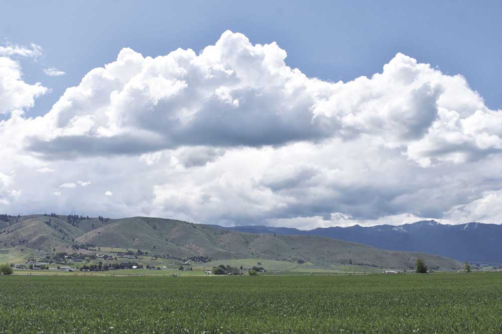
- Thunderheads beginning to form southwest of Baker City on Monday afternoon, June 12, 2023.
Thunderstorms are hardly rare in late spring in Baker County, but the tempests of rain, hail and wind that have enlivened many afternoons over the past month weren’t typical in multiple respects, according to a weather expert.
“Very unusual,” is Jay Breidenbach’s succinct description of the weather pattern that dominated in Eastern Oregon and much of Idaho from mid May until late Tuesday, June 13, when a cold front pushed the warm, abnormally humid air to the east.
That pattern was ideal for forming thunderstorms, said Breidenbach, the warning coordination meteorologist at the National Weather Service’s Boise office.
The crew at the Boise office issues daily forecasts for a region that’s mostly in Idaho but also includes three counties in Oregon — Baker, Malheur and Harney. The agency’s Pendleton office covers most of the rest of Eastern and Central Oregon.
But the storms over the past month have been atypical both in the amount of rain — a few cells have spilled an inch or more of rain in less than an hour — and in the direction many have moved, Breidenbach said.
Normally, winds in the upper atmosphere steer storms from approximately west to east, he said.
But on many recent days, storms have traveled the opposite way, with several cells building first over Idaho and then sweeping west into Oregon.
California influence
Those two factors — rainfall quantity and storm direction — have a common source, Breidenbach said.
That source is also responsible for the warmer than average temperatures that have dominated since the second week of May, he said.
The culprits are a series of upper level low pressure systems that have settled over Southern California and either lingered there or moved slowly into Nevada, Utah or Arizona.
Because air in the upper levels of the atmosphere spins counter-clockwise around the center of a low pressure system (surface winds, which are influenced by terrain and other factors, don’t always follow suit), the location of these systems, to the south and southeast of Baker County, resulted in upper level winds — and thus the movement of storms — being generally east to west, Breidenbach said.
Although it’s not unusual to have a low pressure system set up in California, the persistence of the pattern is abnormal, he said.
“It’s fascinating that as one of the upper lows to our south moves away, another one forms,” Breidenbach said.
A contributing factor is a high pressure system that’s been similarly stubborn, centered in Canada, he said.
Air flows clockwise around high pressure systems, and the placement of the high pressure — to the north of Baker County — has also caused upper atmosphere winds to blow east to west.
“The whole forecast area is kind of stuck in between these two weather systems,” Breidenbach said.
Fueling thunderstorms
The recurring low pressure systems in California, besides bringing easterly air flow to Baker County, have supplied the two key ingredients for concocting thunderstorms, Breidenbach said.
Those are heat and moisture.
Circulation around the low pressure has pushed unusually warm and moist air into Eastern Oregon and Idaho, cutting off the supply of cooler air that comes inland after passing over the chilly water of the North Pacific, propelled by the common westerly winds in the upper atmosphere.
The recent situation is similar to the summer monsoon that spawns much of the annual rainfall in the desert Southwest and occasionally extends into Eastern Oregon and Idaho, although Breidenbach said the monsoon pattern typically doesn’t arrive until mid summer.
The effect of this pattern on temperatures has been obvious.
The average high temperature at the Baker City Airport during May was 71.1 degrees, which is four degrees above average. And that’s despite a cool start to the month, when the temperature didn’t reach 60 on five straight days.
June is also running warmer than usual through its first two weeks. The high temperature topped 70 degrees on 12 of the first 13 days, and reached 80 or above on five days.
The warm air, combined with the high sun angle as the solstice nears, heats the ground and the air just above it, making the air buoyant. So long as a parcel of air remains warmer than the surrounding air, it will continue to go higher, Breidenbach said.
The air will cool as it rises, though, and can hold less water vapor so some of that invisible vapor condenses into water droplets — clouds, in other words.
The key process, though, is that condensation releases heat, Breidenbach said — 570 calories for each gram of water that condenses, to be precise.
The heat released by condensation helps keep a parcel of air warmer than the surrounding air, he said, ensuring that the parcel continues to rise. This perpetuates the process and eventually can transform a benign cumulus cloud into a towering cumulonimbus capable of producing lightning bolts, hail and torrential rain.
The more moisture in the air, the more fuel for storms to form and to grow, Breidenbach said.
Those moisture levels have been near record levels in the region on many days over the past month, he said.
The weather balloon that National Weather Service employees released from their office at the Boise Airport on Tuesday morning, June 13, for instance, measured a water level that’s in the 99th percentile for the date, Breidenbach said.
With so much moisture available, storms will form readily and they’ll dump copious quantities of rain when they reach maturity, he said.
A cell that moved through eastern Malheur County late on June 11 dropped an estimated 1 to 3 inches of rain in a few hours, leading to landslides that covered a section of U.S. Highway 20 between Burns and Vale with several feet of rocks and mud.
May’s total rainfall at the Baker City Airport was 1.7 inches, compared with a long-term average of 1.43 inches. June’s total, buoyed by a cloudburst on Tuesday afternoon, June 13 that dropped almost one-third of an inch in less than an hour, is also running above average, at 0.82 through June 13. The average for the month is 1.25 inches.
Moisture matters
So if heat is an ingredient in thunderstorms, why don’t they bombard the region whenever the temperature tops 90, as it often does during July, August and into September?
The answer again involves moisture in the atmosphere, Breidenbach said.
During a typical mid-summer afternoon, he said, there is less than half as much moisture in the air than the weather balloon measured on June 13.
Although the intense heat will warm the ground and cause air to rise, the scarcity of moisture means there’s little condensation, and thus little extra heat is released to keep a parcel buoyant, Breidenbach said.
This comparatively dry air might rise to 10,000 feet above the ground before enough vapor condenses to even form scattered cumulus, he said. But there’s not enough moisture, in such conditions, to fuel thunderstorms.
Boosting the moisture level even by a modest amount, though, can trigger widespread storms.
Over the past month or so, the air has been so soggy that even temperatures in the 70s and 80s are more than sufficient to start the process, known as “convection,” that concludes with thunder, lightning and a downpour.
Humidity, dewpoint
Although most people don’t have weather balloons equipped with sensitive instruments to sample what’s going on in the atmosphere, Breidenbach said even a simple hygrometer, which measures humidity, can help people gauge the likelihood that storms will form.
Humidity is expressed as a percentage. The higher the percentage, the closer the air is to being saturated, meaning it couldn’t hold any more moisture without some of the moisture condensing into clouds.
That’s why the humidity on a foggy day is likely to be either 100% or well into the 90s — the air can’t hold all its vapor so some of it condenses into fog, which is just a low-lying cloud.
Humidity is directly related to another measurement you’ll often seen in weather reports — dewpoint.
The dewpoint is a temperature rather than a percentage. The dewpoint is the temperature to which the air would have to be cooled to reach 100% humidity.
The drier the air, the greater the difference between the dewpoint and the air temperature.
On the aforementioned foggy day, the dewpoint and temperature might be identical.
But on a typical July afternoon in Baker County, Breidenbach said, when the air temperature is 95 degrees and the humidity is 15%, the dewpoint would be 41 — a difference of 54 degrees.
Thunderstorms aren’t likely to form in such conditions.
But keep the temperature at 95 and boost the humidity to just 30 percent — far from the sticky conditions people in the South and Midwest frequently endure, but not abnormal around here when monsoon moisture moves in from the southwest — and the dewpoint jumps to a thunderstorm-friendly 59.
Breidenbach said the warm, moist air that’s been circulating north into our region recently has pushed daytime humidity levels to around 50% or even higher on many days. When the atmosphere is that juicy, he said, the temperature doesn’t have to reach 90 to jumpstart storms.
On Tuesday, June 13, for instance, the temperature at the Baker City Airport at 6:35 p.m. was 72 degrees. But the humidity was 73%, yielding a dewpoint of 63. The abnormally humid conditions — dewpoints rarely exceed 60 degrees here — contributed to the torrential rain that fell on Baker City earlier in the day.
The weather pattern that has persisted in Eastern Oregon and Western Idaho for most of the past month, with above-average temperatures and frequent thunderstorms, changed abruptly this week.
A cold front swept through the region late Tuesday, June 13, bringing cooler and much drier air. The dewpoint, which reflects the humidity of the air, plunged from an abnormally high 63 degrees at 6:35 p.m. on Tuesday to 39 at 2:20 a.m. on Wednesday, June 14.
An even more significant switch is forecast for late in the weekend and early next week. The National Weather Service predicts a stronger storm, more typical of early spring than late, to move in from the North Pacific. The high temperature might not reach 60 degrees in Baker City early next week, and the snow level could briefly drop to 6,000 feet. Nighttime temperatures likely will dip into the 30s in Baker City.


-
eEdition
-

-
